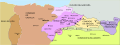
English: España / Espanya / Espainiako (Spain) Maps showing all or most of the territory (geographic area) of modern-day Spain - as the lands were in the 12th century (1101-1200 CE)
Español: Mapas que muestran todo o la mayor parte del territorio (el área geográfica) de la España actual (Spain) - como eran las tierras en el siglo XII (1101-1200 EC)
Català: Mapes que mostren tot o la major part del territori (l'àrea geogràfica) de l'Espanya actual (Spain) - com eren les terres al segle XII (1101-1200 EC)
Euskara: Gaur egungo Espainiako (Spain) lurralde osoa edo gehiena (hau da, eremu geografiloa) erakusten duten mapak da XII. mendean (1101-1200 K.o.) lurrak ziren bezala
See Wikimedia Commons Atlas of Spain for a general overview of the territory including its evolution in European history.
Additional maps related to the history of Spain (including larger entities comprising or controlling the territory, smaller entities within the territory, and colonial territories) can be found at Maps of the history of Spain.


 Spain - as the lands were in the 12th century (1101-1200 CE)
.jpg/120px-Comtats_catalans_s._VIII-XII_(modificat).jpg) Comtats catalans s. VIII-XII (modificat).jpg 1,882 × 1,992; 656 KB
Comtats catalans s. VIII-XII (modificat).jpg 1,882 × 1,992; 656 KB Comtats catalans s. VIII-XII-es.svg 659 × 707; 439 KB
 Conquistas de la Corona de Aragón.jpg 1,258 × 1,582; 1.12 MB
 Reino de Pamplona Sancho III.svg 2,779 × 1,050; 525 KB
 Territorio Ramon Berenguer IV-ar.svg 2,555 × 2,825; 1.01 MB
 Territorio Ramon Berenguer IV-ca.svg 2,555 × 2,825; 499 KB
 Territorio Ramon Berenguer IV-es.svg 2,555 × 2,825; 759 KB
 Territorio Ramon Berenguer IV-v2-es.svg 2,462 × 2,003; 3.3 MB
 Tractat de Tudilén -1151-.svg 3,075 × 3,556; 206 KB
 Tractat de Tudilén -1151-es.svg 3,075 × 3,556; 985 KB
 TRATADO DE CAZOLA 1179.jpg 3,179 × 3,615; 788 KB
.jpg)


